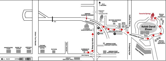
| Keywords of the Map: |
| Tamarind Hill, Menara Kayangan Apartments, Menara Indah Apartments, Kelab Darul Ehsan, SPCA, ISKL, Mutiara Grammar School, Flamingo Hotel & Institute, Gleneagles Hospital, Sucasa, Crown Princess Hotel, Ampang Park, Hampshire Part Jalan Tun Razak, Jalan Jelatek, Jalan Ampang, Jalan Ulu Klang, Jalan Kerja Air Lama, Ampang Elevated Highway 68000 |
| |
|
|
| About This Map: |
| Tamarind Springs, Ampang () |
| From Jalan Ampang:
1. Turn left on to Jalan Ulu Klang at the Ampang Point flyover. 2. Then turn right at the first traffic light (opposite the Flamingo Hotel). 3. Go straight, pass the International School of KL (on your left) all the way to Kelab Darul Ehsan (KDE). 4. Pass the entrance of KDE, follow the road around the golf course (for about 500 metres) until you reach the entrance for Tamarind Springs - located opposite Menara Indah Apartments. Via the Ampang Elevated Highway: 1. Take exit 1204A to Jalan Kerja Air Lama. 2. After the off ramp, go straight, pass the International School of KL (on your left) all the way to Kelab Darul Ehsan (KDE). 3. Pass the entrance of KDE, follow the road around the golf course (for about 500 metres) until you reach the entrance for Tamarind Springs - located opposite Menara Indah Apartments. | |
8, Jalan Awan, Ulu Kelang, 68000, Ampang, Selangor |
| |
| |
| |
|